The 12 Best Hiking Trails Gatlinburg Has to Offer!
- Gatlinburg is a prime destination for outdoor activities, especially due to its proximity to the Great Smoky Mountains National Park, which spans over 522,419 acres.
- Researching before heading out is essential, as not all hiking trails are the same; considerations like trail difficulty, weather conditions, and group needs (like child-friendly options) can significantly impact the experience.
- There are numerous beautiful trails in the area, including popular ones like Alum Cave Trail to Mount LeConte, Rainbow Falls, Grotto Falls, and Cades Cove, each offering unique views and experiences.
- Many trails provide opportunities for seeing wildlife, waterfalls, and historical landmarks, enhancing the hiking experience for visitors.
- Safety tips such as staying hydrated, proper footwear, and informing someone about your hike, along with the motto "Hike your own hike," are crucial for an enjoyable outing in the Smoky Mountains.
The 12 Best Hiking Trails Gatlinburg Has to Offer!
From the tippy-top of the city’s very own Space Needle to the underground caves of the Forbidden Caverns, it’s clear that after you're done checking in to your Gatlinburg hotel, there’s a lot to see and do as you explore this amazing destination from top to bottom. But even with all these attractions, Gatlinburg’s biggest draw is something that comes au naturel to the region: its proximity to the Great Smoky Mountains National Park (and all the views and trails that go with the territory). Luckily, all you have to do to take advantage of it is pack some hiking boots, stretch out those limbs, and do a little bit of homework before taking off (don’t worry, we’re here to help with that).

The Top 12 Hiking Trails in Gatlinburg, Tennessee
The Great Smoky Mountains National Park is about 522,419 acres which means, you probably won’t see all of it in a weekend. So, to make the most of your trip to the most visited national park in the country, it’s important to do a little research first. After all, not every trail is created equal. We suggest asking yourself a few questions to start off, like: Do I need child-friendly trails? Am I an experienced hiker or a newbie? What will the weather be like during my stay? How much time am I willing to put in before I get the visual payoff? All of these questions are important to consider as they can help you choose the right trails for you and your group.
So, let’s get started. If you’re interested in taking in some of mother nature’s finest work during your stay in Gatlinburg, Tennessee here are our picks for the top 12 hiking trails:
1 | Alum Cave Trail to Mount LeConte | It may be just the third tallest mountain in the Great Smoky Mountain National Park, but Mount LeConte is arguably the most famous and it’s easy to see why—panoramic views, unique geological features, and a rich history to boot. To reach it, you have five trail options but the most popular is Alum Cave Trail for its sightseeing perks. On the way up, Alum Cave Trail passes by a variety of notable landmarks, including Arch Rock, Inspiration Point, the Duckhawk Peaks, and Cliff Top. That said, this hike isn’t for the weak willed—it’s a short 5-miles, but it’s steep and strenuous on the way up.
PRO HIKING TIP | At 2.2 miles, hikers will reach Alum Cave, which really isn't a cave, but is actually a concaved bluff, about 80 feet in height, and roughly 500 feet in length. During the warmer months of the year, water drips off from the ledges above which turn into large icicles in winter. If you go in winter, every couple of minutes an icicle may drop down and explode on the rocks below. Just BE CAREFUL! It's an exciting but adventurous hike!
WHERE: 107 Park Headquarters Road, Gatlinburg, TN 37738 | WHO: 865-436-1200
RELATED ARTICLES
2 | Rainbow Falls | If waterfalls are big on your hiking checklist, then Rainbow Falls is the right trail for you. Start off your journey just outside Gatlinburg and make your way 5.4-miles through the Great Smoky Mountains National Park where you’ll come to an 80-foot tall waterfall, a.k.a. Rainbow Falls, a.k.a the tallest single-drop waterfall in the entire park. It’s a rough and rocky trail, but if you visit on a beautiful sunny day, you might be able to see the mist-induced rainbows that give it its name.
PRO HIKING TIP | Start your hike first thing in the morning, which is the period of time the sun's angle will be perfect for waterfall photography. Also, the rocks around the falls are quite slippery due to mist and algae, so do NOT ATTEMPT TO CLIMB THEM.
WHERE: 107 Park Headquarters Road, Gatlinburg, TN 37738 | WHO: 865-436-1200
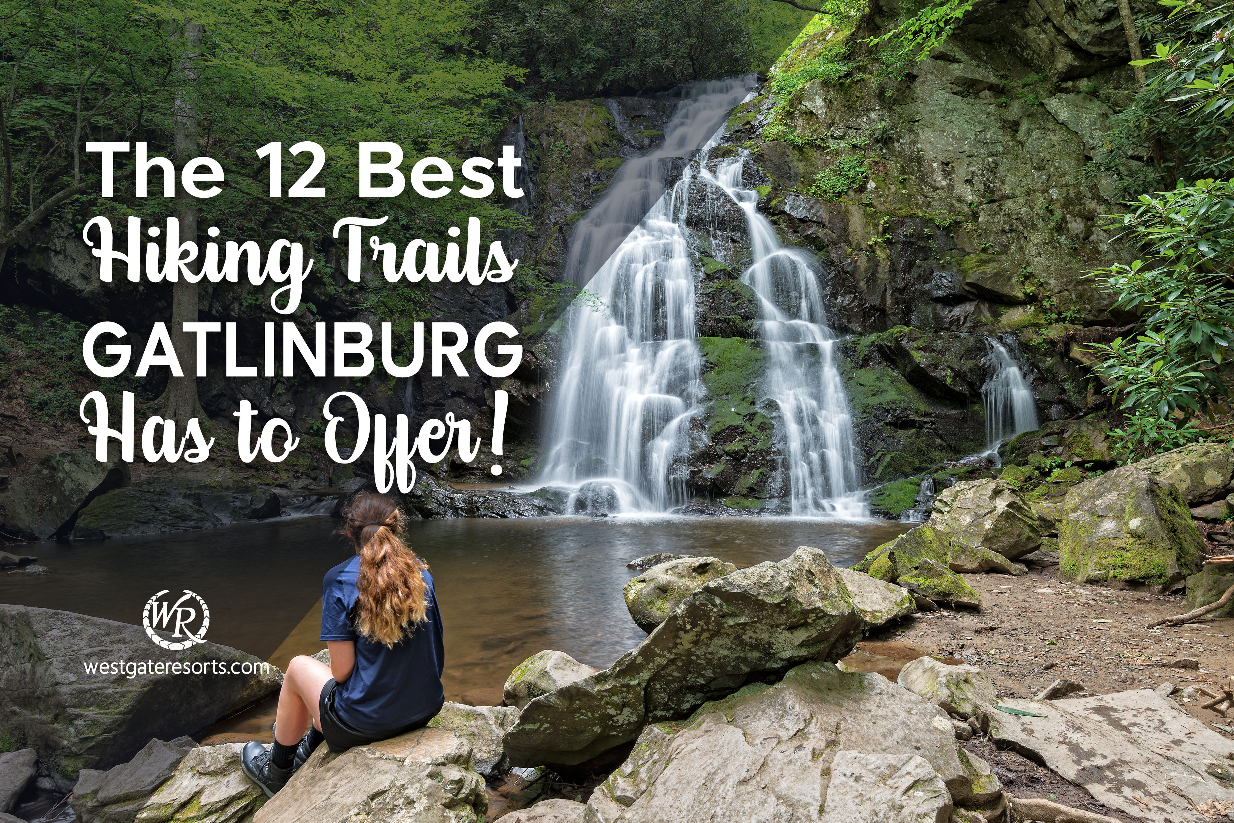
3 | Grotto Falls | For a waterfall experience without the rough and rocky terrain, hike up to Grotto Falls, a kid-friendly alternative that still delivers nature, sightseeing, and rushing waters. Coming in at just 2.6 miles and nearly completed shaded by a hemlock canopy, this hike is a great choice for beginner and slow-paced hikers, as well as summer hikers. And did we mention it’s the only waterfall in the Smokies you can walk behind? Take a snapshot behind the falls and get a little splash of waterfall water and you’ll be ready to make the trek back, even on a hot summer’s day.
PRO HIKING TIP | The 25-foot high waterfall is great shade for hikers in the summer AND a habitat for CUTE salamanders as well! See if you can spot one! As you walk behind the waterfall you'll feel the power of the water plunging into the pool in front of you. Watch your step here as this footing is usually wet and slick.
WHERE: Trillium Gap Trail, Gatlinburg, TN 37738 | WHO: 865-436-1291
4 | Cades Cove | What started off as a Cherokee settlement turned European settlement, then later became a center for Tennessee’s abolitionist movement, is now one of the Great Smoky Mountains National Park’s most popular spots. Though the Cades Cove has plenty of natural beauty to ogle at (hello, wildflowers and mountain backdrops!) one of its most appealing factors is the historical landmarks that remain on the trail to this day—including restored churches, old grist mills, and pioneer log cabins. While it is definitely a beautiful hike that shouldn’t be missed, visitors can choose to bike, run, or drive through as well.
PRO HIKING TIP | Hands Down, if you are on a mission to see bears, elk, foxes, birds, deer, and other wildlife, Cades Cove is your best chance! This area is protected and has tons of food and water sources for its abundant wildlife population, so you'll be sure to see them. Feel free to explore!
WHERE: 1 Cades Cove Loop Road, Great Smoky Mountains National Park, TN 37882 | WHO: 865-436-7318
5 | Gregory Bald Hike | Okay, this one is for all of you super-hikers out there. Gregory Bald hike is a tough one, but definitely worth the bulging calf muscles you’ll most certainly have after its done. Coming in at 11.3 miles and a total of 3,020 feet of elevation gained throughout the hike, Gregory Bald makes you work for its most impressive feature: a sea of Flame Azaleas in bloom every summer. Plus, amazing mountain-top views and glimpses of the trail’s majestic wildlife. But hey, is it really any surprise that you’ve got to work hard for those views and not to mention those Instagram shots? Exactly.
PRO HIKING TIP | The flame azalea flowers reach their maximum development on Gregory Bald and have made this area worthy of being a National Park fave due to the "riot of colors" they produce,... prompting many hikers to say that in this area, "the hills are alive with the sound of music."
WHERE: 107 Park Headquarters Road, Gatlinburg, TN 37738 | WHO: 865-436-1200
6 | Clingmans Dome | If you’re afraid of heights, move along—standing at 6,643-feet tall, Clingmans Dome is not for the faint of heart (or weak of legs). That said, as the highest point in the Great Smoky Mountains National Park, Clingmans Dome offers the kind of views that you just can’t get anywhere else. We’re talking 360-degree, 100-mile views of the Smokies that make the strenuous hike up completely worth it in our book. Just be sure to stretch and bring lots of water before embarking on the trek.
PRO HIKING TIP | Just after World War II, this area was the site of a military plane crash. On June 12, 1946, a B-29 Flying Superfortress smashed into Clingmans Dome during a night navigational flight. The aircraft crashed just north of the Appalachian Trail, roughly one-eigth of a mile to the east of where the Clingmans Dome Tower now stands. People still find historical evidence of the crash and debris to this day.
WHERE: 107 Park Headquarters Road, Gatlinburg, TN 37738 | WHO: 865-436-1200
7 | Abrams Falls | Despite being just 20-feet tall, the popular Abrams Falls is the Great Smoky Mountains National Park’s most voluminous waterfall—and therefore, one of its most scenic. To take a look, just travel 5.2 miles (roundtrip) along Abrams Creek, a route that is picturesque in its own right, trust us. It’s a moderate hike, which means bring the right gear and prepare for some elevation, even if it’s a short trip.
PRO HIKING TIP | At about 2.6 miles, hikers reach the short side-trail that leads to Abrams Falls. Turn left and cross the footbridge to reach a nice "beach" area to view this gorgeous waterfall.
WHERE: 107 Park Headquarters Road, Gatlinburg, TN 37738 | WHO: 865-436-1200
8 | Laurel Falls Trail | If you’ve ever seen a snapshot of a Great Smoky Mountain waterfall on an Instagram or Facebook post, chances are high you were looking at Laurel Falls. It’s a short 2.6-mile walk, making it easily accessible to all kinds of Smoky Mountain visitors. And with an 80-foot cascade, it’s easy to see why Laurel Falls is one of the most-photographed spots in the entirety of the park and one you wouldn’t want to miss.
PRO HIKING TIP | This is a family favorite for hiking trails, and you'll find a lot of families with young children on this extremely popular trail. If you plan to hike with children, please keep a close eye on them at all times as the trail passes next to some steep drop-offs, especially in areas closer to the falls.
WHERE: Little River Road, Gatlinburg, Great Smoky Mountains National Park, TN 37738 | WHO: 865-436-7318
9 | Baskin Creek Falls | Here's another great hike for those looking to get some great waterfall pics! The trail to Baskins Creek Falls starts with a short easy climb after which the terrain levels out, exposing some fantastic views of the mountains in the west, as well as a few glimpses of Gatlinburg - if you're hiking in the winter or early spring. The last bit of the trail before you hit the falls is a little steep so watch your step! The payoff, however, is a magnificent 40-foot, two-tiered waterfall that might be the most underrated Instagram-worthy waterfall in all the Great Smoky Mountains, and typically doubles as a super-selfie taking scenario, and even a great spot to 'bask' in the shade for a sit down picnic or snack.
PRO HIKING TIP | Funny story! These falls and the creek connected to them supposedly got their name from a local hunter known as Bearskin Joe, and over time, the pronunciation of his name lazily got morphed into "Baskins", hence - Baskin Falls! Happy baskin'! The total round trip on this hike is about 3 miles, so imminently do-able even for novices!
WHERE: Baskins Creek Trail, Gatlinburg, TN 37738 | WHO: 865-436-1200
10 | Chimney Tops Trail | This two-mile hike might be a short one, but what the Chimney Tops Trail lacks in miles it makes up for in feet—1,375 feet to be exact. Though this trail was affected by a wildfire in 2016, it was reopened in 2017 with a newly constructed observation point which gives way to amazing mountain views. As one of the park’s most popular trails, this one is a must-see.
PRO HIKING TIP | Popular because of its relatively short length and panoramic views, this trail has a very steep hike towards the end - in fact, many hikers don't even reach the top! The first half of the trail is somewhat easy. However, to reach the summit area hikers have to climb more than 960 feet over the course of the last mile!
WHERE: 107 Park Headquarters Road, Gatlinburg, TN 37738 | WHO: 865-436-1200
11 | Trillium Gap Trail to Mount LeConte | When we say Trillium Gap Trail has it all, we mean it. We’re talking waterfalls, mountain views, and the LeConte Ldoge. As one of the five trails leading to Mount LeConte, you’ll still end up at the beautiful third-highest Smoky Mountain peak but with a few different steps along the way—including Grotto Falls, Rainbow Falls Trail, and the world-class views of Mount LeConte’s Myrtle Point.
PRO HIKING TIP | The summit of this hike, known as High Top, is at the 6.9-mile mark. You'll know you've reached this point when you get to the large cairn just off the main trail to your right.
WHERE: Roaring Fork Motor Nature Trail, Gatlinburg, TN 37738 | WHO: 865-436-1200
12 | Gatlinburg Trail | Last but not least, the Gatlinburg Trail is a must-do since you’re in the trail’s namesake city. It’s an easy trail for the Great Smoky Mountains National Park, but you’ll still see plenty of breathtaking vistas and fascinating historical log cabins along the way and it starts off conveniently close to Sugarland Distillery—bingo! Bonus points: The Gatlinburg Trail is one of only two trails in the park that allows dogs, so if you’re traveling with a furry friend, be sure to check out this trail.
PRO HIKING TIP | At about 1.2 miles, the trail begins to change into the Park Headquarters Road. Eventually the trail completely disappears, and you'll be walking on the road that continues towards the visitor center. From this point you'll follow a sidewalk to reach the visitor center and eventually pass the historic park headquarters building. Just before reaching the Sugarlands Visitor Center, you'll reach a side trail to Cataract Falls. This waterfall is roughly one-half mile away if you wish to see it and is well worth it - a hidden gem!
WHERE: US-441, Sugarlands Visitor Center, Great Smoky Mountains National Park, TN | WHO: 865-436-1200
Use Our Handy Trail Map to Find Your Way Around!

Explore Gatlinburg’s Best Hiking Trails
There are more than 850 miles of hiking trails in the Great Smoky Mountains National Park and they’re all different. Whether it’s elevation differences, natural landmarks, final vantage points, or just the roundtrip distance of the trails, there are a lot of factors to consider before embarking on your Smoky Mountain hike. With this handy list of the top hiking trails in Gatlinburg, we hope you’re able to find the right trail for you and your group.
Once you’ve decided on a trail though, be sure to let someone know where you’re going, to bring plenty of food and water (especially on summer hikes), to wear proper clothing and footwear, and to be honest with your limitations. And always remember the hikers’ motto: Hike your own hike—there is no “wrong” way to hike.
To round out the rest of your Gatlinburg trip, check out our list of 51 Things to Do in Gatlinburg, Tennessee, or our 10 Top Attractions for Families in Gatlinburg.
RELATED ARTICLE:

At Westgate Resorts, when you Check-In, there’s a LOT to Check-Out! Your Gatlinburg vacation awaits! Explore our Gatlinburg resorts today or talk with a vacation planner at 888-852-2959 or 407-355-2690.
* Westgate Resorts is in no way affiliated with the attractions featured in this article. Items or places listed are current as of the publishing date of this article. Please call or visit the respective website for the most up-to-date offerings and details.
When You Check-in, There's a Lot to Check Out
Sign up for our newsletter and check-in to great offers, secret stuff, and special events.